
Geographies of Manhattan Geographies of Manhattan
Jun 17, 2011
- mvdb
Final presentation
Geographics of Manhattan
Group 1 made four design proposals for Randall's Island and Wards Island and choose not to make a overall, grand idea . The location contains three bridges that dominate the site, and that connect the boroughs of Manhattan, Queens, and The Bronx via Randall's Island and Wards Island. But what if all cars are banned from Manhattan, what will be the future of the island? The group looked at:
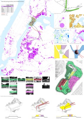
- Food production, and transportation. To bring food production back into Manhattan, Randall’s Island will serve as hub. The island becomes the marketplace for the city.
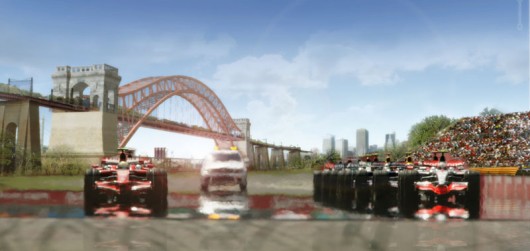
- Leisure. A leisure icon is needed for the island. The existing infrastructure is used to make a racing track, once a year the Grand Prix of New York takes place on Randall’s Island.
- Waste disposal. New York exports most of her waste, only a small amount is being recycled in the city. By making waste mountains on Randall’s Island, it will not only save the city a lot of money, it will also change the geography and create a new Manhattan skyline. The island will turn into a pedestrian area with a luxurious new bay.
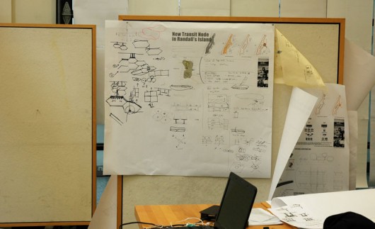
- Infrastructure transit knot. The new transit knot takes the honeycomb as a model. This form makes it possible to expand infinitely.
Download the presentation (pdf)
Download the panels (pdf)
Jun 5, 2011
24h to go
Jun 2, 2011
Work in progress
Group 1 is making design proposals for Randall's Island and Wards Island. The location contain three bridges that dominate the site, and that connect the boroughs of Manhattan, Queens, and The Bronx via Randall's Island and Wards Island. But what if all cars are banned from Manhattan, what will be the future of the island? How can the islands be regenerated and reconfigurated and what can happen to the bridges?
The first two day the participants made visions departing from:
- production and manufacturing (goods as well as services)
- leisure, sports, parks
- waste disposal and treatment
- infrastructure transit knot
Like the guys in charge of production and manufacturing see the island as a important knot of production and manufacture on the scale of the east side of New York. In their view the Triborough Bridge, which is the most striking piece of infrastructure on the island, not only divide the island in two but is also connects it with New York. Therefore they propose the Triborough Bridge to become a combination of storage and production on one site, and a market on the other. The hole thing they cover over carpet-like and will be a huge pedestrian zone.

May 31, 2011
May 3, 2011
May 3, 2011
May 3, 2011
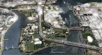
The brief: GEOGRAPHIES OF MANHATTAN: The Triborough Bridge
OVERVIEW The workshop aims to unlock the architectural potential of an infrastructural element by reconfiguring its status between system and object. It expands the geographic scope of the Capital City project beyond the islandhood status of Manhattan, by incorporating a peripheral infrastructure and the neighboring boroughs into the design of Future New York. It examines as such the intertwined paradigms of Geography, Infrastructure, and Urban Form.
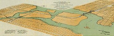
The site is the Triborough Bridge, a complex of three separate bridges that connect the boroughs of Manhattan, Queens, and The Bronx via the two landfill‐joined Randall's Island and Wards Island. Through the bridge, the workshop aims to explore a range of possibilities for architecture between megaform and megastructure.
HISTORY Built at the height of the Great Depression, the Triborough Bridge was one of the largest and most expensive New Deal projects. In the 1920’s and 1930’s, New York City traffic increased rapidly as the population grew and car ownership became more common. Creating a network of high‐speed roadways was crucial for the city’s continued growth, and with four of the five boroughs on islands, bridges would be the key to regional mobility. The Triborough Bridge was designed exclusively for automobile traffic and its construction was coordinated to connect it to the region’s emerging highway system. When it opened in 1936, its three and a half miles of bridge included a suspension bridge to Queens, a vertical lift span bridge to Manhattan and a truss bridge to the Bronx ‐‐all intersecting at a huge traffic junction on Randall’s Island. Robert Moses always regarded the Triborough Bridge as a way of uniting the city and the metropolitan area. “It has long been a cherished ambition of mine to weave together the loose strands and frayed edges of New York’s metropolitan arterial tapestry,” he wrote. “The Triborough Bridge Authority has provided the warp on the metropolitan loom, the heavier threads across which the lighter ones are woven.”
DESCRIPTION The workshop examines the geographies of the Bridge in a Future New York, in which cars are banned from entering Manhattan. The students can choose to focus on Randall island, on the reconfiguration (and redesign) of the bridge, or on both depending on their individual design strategies. Additional programs on Randall Island, such as parking garages, a multi‐modal transportation hub, as well as leisure and entertainment facilities on the waterfront will also be entertained accordingly. The studio proposes that addressing a geographic conception of infrastructure is necessary to effectively impact the scale of the metropolis.
METHODS The workshop builds on the research agenda of its instructors, founding editors of the New Geographies journal (www.gsd.harvard.edu/newgeographies). The journal proposes Geography as a paradigm in response to a condition in which designers are increasingly being compelled to transform larger contexts and address questions (such as infrastructure, urban systems, and regional questions), which had previously been confined to the domains of engineering, ecology, or regional planning. The need to address these 'geographic' aspects has encouraged designers to re‐examine their tools to link together such attributes all while opening up a range of technical and formal possibilities for design.
DELIVERABLES 2 A1 panels + Powerpoint, to be submitted on Monday, June 6.
_______________________________________
Rania Ghosn is an architect and geographer. She is currently a lecturer at the MIT School of Architecture and a postdoctoral fellow at Boston University. Ghosn received her Bachelor of Architecture from American University of Beirut, holds a masters degree from University College London Geography Department and a doctoral degree from Harvard University Graduate School of Design. Ghosn is founding editor of the journal New Geographies, which focuses on contemporary issues of urbanism and architecture, and editor-in-chief of New Geographies #2: Landscapes of Energy.
El Hadi Jazairy is Lecturer in the Department of Architecture at MIT where he co-teaches the “After-City Baltimore” studio. He received a Diplome d'Architecte from La Cambre in Brussels, a Master of Architecture from Cornell University and a Doctorate of Design from Harvard University. Professionally, he collaborated for over 5 years with Elia Zenghelis and Xaveer de Geyter. He is founding editor of the New Geographies journal, and editor-in-chief of New Geographies #4: Scales of the Earth.
El Hadi Jazairy is Lecturer in the Department of Architecture at MIT where he co-teaches the “After-City Baltimore” studio. He received a Diplome d'Architecte from La Cambre in Brussels, a Master of Architecture from Cornell University and a Doctorate of Design from Harvard University. Professionally, he collaborated for over 5 years with Elia Zenghelis and Xaveer de Geyter. He is founding editor of the New Geographies journal, and editor-in-chief of New Geographies #4: Scales of the Earth.

Workshop leaders: Rania Ghosn is an architect and geographer, and El Hadi Jazairy is lecturer in the Department of Architecture at MIT.
