
table-6 Table 6 free fertile land
María Martínez-Morón, Icao Tiseli, Constanza Jara, Tetiana Hlushchenko, Nataliia Butyrina
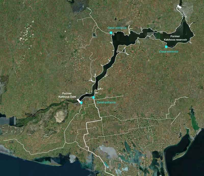
In this workshop we want to look at the region around the destroyed Kakhova Dam, from the perspective of building a sustainable food and water system.
The Kakhova Dam is one of the 7 major dams on the Dnipro River built by the Soviet regime. The reservoirs were used to generate electricity, but also to irrigate extensive agricultural areas. A large part of these areas consist of ‘Tsjernozem soils’. This type of soil is exceptionally fertile and is among the most productive agricultural soils in the world.
However, overexploitation is taking place. This leads to problems with erosion, soil degradation, excessive use of agricultural chemicals. It is estimated that Ukraine now loses 500 million tons of Tsjernozem soil per year due to erosion. The large irrigation systems have low irrigation efficiency and high energy consumption, energy costs and CO2 emissions.
Climate change is making the southern region increasingly warmer and drier, making an agricultural transition unavoidable. The higher temperatures make these areas less suitable for potatoes and sugar beets, but more - with the availability of water - for the cultivation of eggplant, broccoli, pumpkin, mustard seed, peas, watermelon, zucchini, cabbage, coriander, corn, alfalfa , carrot, cucumber, red peppers, sweet peppers, tomatoes, oats, millet, sunflower, soy, onions, sorghum, rapeseed, barley, wheat and flax.
The destruction of the Kakhova Dam provides a need and opportunity to re-examine the agro-ecological system of this region, as part of the country's reconstruction. There is a need to achieve climate-smart, sustainable agriculture, with other crops and economical water use. A new system that is social, circular en energy efficient. A system that, in addition to food, also produces sustainable energy, bio-based building materials, forests, nature and landscape quality.
In the workshop we want to explore spatial concepts on a larger scale and then zoom in on one of the areas that was irrigated from the Kahova reservoir. At this scale, the connection between the former reservoir, the villages, the people, the agricultural companies, the irrigation canals, natural rivers and agricultural areas comes into focus.
 Ruut van Paridon is a landscape architect. He has a landscape design office in Amsterdam, together with Karen de Groot. He studied at the academy of Academy of Architecture in Amsterdam, where he graduated in 2003 with the project Tuinenrijk/Knooperven. This is a bottom-up landscape development strategy for the small-scale landscape of the eastern Netherlands.
Ruut has a lot of experience with projects at the interface of ecology, water, agriculture, energy and spatial design. He assumes several points of view: from viewpoint of the program, the specific qualities of the place, and from the viewpoint of the people who make, use and manage this specific site.
The aim of the agency is to design characteristic landscapes where people feel connected to, and where people are willing to take care for. In 2016, the agency worked on the IABR Groningen, which explored how an economy based on renewable energy and low CO2 emissions can provide an attractive perspective for the region. This led to three concepts: the Eemsdollard as an energy bay, the bio-based north and sustainable, safe villages.

Lidiia Chyzhevska F, Consultant, PhD arch. Landscape Architecture and Urban Planning (KNUBA) Holds a BA in architecture and MSc in Urban Planning, PhD Landscape Architecture and Urban Planning, has ten years of experience in Ukrainian spatial and urban planning projects on land management, landscape planning, and urban planning funded by GIZ, USAID, UKAID, UNDP. Senior Consultant in the field of Spatial planning and natural resources management, climate resilience in U-LEAD project for increase capacity building for cities and municipalities. The chief architect of the Comprehensive Spatial development plat of Rohan Municipality in Kharkiv Region, which combines urban planning document landscape planning and climate change adaptation, implementation of using various energy sources to make the municipality more sustainable and resilient.
Table 1 Future proof just land use and land ownership
Table 2 Innovative Rainwater Management
Table 3 strategies for regeneration of the river bed and river
Table 4 BACKWARDS FREESTYLE
Table 5 The Space that Water Leaves Behind
Table 6 free fertile land
Table 7 System mind-mapping
Table 8 Great meadow
Table 9 Urgent Urbanism
